Posts

Showing posts with the label Hiking

Second visit to Bukit Kutu (March 2016)

Image
I had my second visit to Bukit Kutu on 5 March 2016. It was also the day for KubUltra trail run in the morning. We reached the hiking spot at 830am and there were many cars parked along the road. Guess Saturday is always a good day to start something exciting. We had the very first trip to Kutu back in June last year, please click here for the post. This time, I had one 1.5l water, two 500ml 100plus drinks, packed lunch, two breads and few Snickers in my backpack. At the end of hike, we consumed all the fluids, with only the breads and Snickers left. We started the hike at 9am and reach the Batu Tedung Checkpoint at 1030am. After 10-mins break and taking photos around with the incredibly huge boulders, we proceed to the chimney area where the Kutu summit is just close by. Ascending... Batu Tedung Checkpoint. Finally, we reached the summit at 12pm. We took few climbs further to the viewing point using the ladders. According to site information , the panoramic vi...

Taiping Cross Country (TCC) 2015 Race Report

Image
The first Sunday of August 2015, the day for Taiping Cross Country 2015. It is aimed at creating awareness amongst runners towards running in green. Prior to race day, the participants were requested to carry their own hydration pack to reduce the water cup usage while running, as part of “Save the Rainforest” initiatives. Taiping Cross Country 2015 "Save the Rainforest" Thousands runners were gathering at Hua Lian Secondary School on that morning. Two competitive categories of 15 km and 7 km were brought in. The 15 km category flagged off at 7 am. Pose (Photo source:  TCC Facebook ) Soon enough the runners find themselves passing by the serene Taiping Lake, mesmerized with expanse of calm water behold (for more race route details, please click here ). The race course has successfully set the participants running in various terrains, grass fields, tar road, hill trek, rocks, river stream and bridge crossing. Furthermore, we had to trek up the hill or...

Bukit Kutu

Image
Since the last Apek Hill hiking, I am going for Bukit Kutu after 2 months. It is situated near to Kuala Kubu Bharu (KKB) at Hulu Selangor, where you will pass through Selangor Dam during the way to Fraser Hill. It took us approximately 2 hours driving journey from KL. The trekking at KKB has gained its popularity due to the popular Lata Medang waterfall and Bukit Kutu. As it is fasting month, only threes cars were spotted at the car parking area on the Saturday morning.  At 830 am, we started to ascend. First part of trek was an easy flat route, before entering the bamboo forest. Along the route, falling bamboos were scattered around and we have to bend down most times with stems overhead. We grabbed some rest at Checkpoint 5 (C5) before heading up again. Early trail. Bamboos overhead. Scorpion vs giant millipede. We reached Bukit Kutu peak at 12pm, standing tall at 3456 feet above ground. Taking three more ladders, our sights are c...

Setia Alam Trail - tips and guides

Image
The first Tuesday of February 2015, it was the Public Holiday for Thaipusam. I had planned for my first hike at Setia Alam, realising the traffic at KL and parts of area in Selangor going to be terrible with people flocking to Batu Caves for celebration. As early as 730am, we reached the hiking spot after meeting up with Wewen from Klang. We started at trail point A. The gathering point is a huge piece of empty land with some construction planning on the go. The aim for today is the Peak Garden and we took approx. 1 hour to reach the destination. Although the peak stands at 240m and certainly not as tall as the previous hills taken, it was good with high winds and sceneries worth-the-adventure. Be surprised that you can view the KL Twin Towers from here. We parked our car next to this water tank. The starting point. Source:  Setia Alam Trail View from the peak garden. Construction going on.. The peak garden! Here looked more like a farm! ...

Bukit Kiara - The North Face Trail Running Programme

Image
The 8 th TNF Trail Running Programme w as held on 15 November 2014. It was a monthly gathering kind event for a bunch of avid hikers in the Klang Valley. This time, it was at Taman Lembah Kiara. This is my first visit to the Bukit Kiara and according to the organiser, distance covered for the day would be around 4.6 km. The warm up session started as early as 7am followed by trail run. We were given some briefing on the route and were told that there were sweepers at the back making sure nobody is left behind. Along the route, we found that markings purposely left by the organizers few days ago were not in sight due to heavy downpour in the night before. What a pity as much effort put does not help. We finished the trail within an hour. It was an easy trekking. We were given post race drink and the third stamp on TNF Count Card. Hooray! With these 3 stamps, we are entitled to a TNF training tee for free! The park is well-equipped with facilities for public to do ...

Saga Hill - The North Face Trail Running Programme

Image
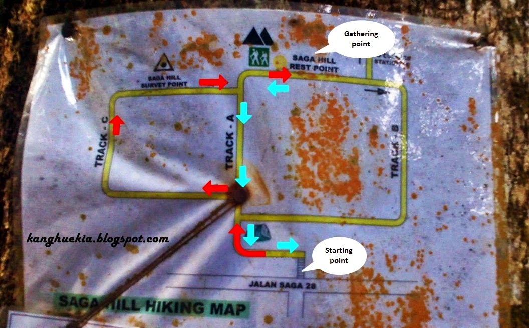
27th September 2014, we are going to Saga Hill again. This is our second visit in less than two months time. We are joining the monthly hiking event organized by The North Face Malaysia. The assembly point is at the car park area nearby the Saga entrance. The hike started at 715am after the warm up session. Our hiking trail of the day. Ascending (Red arrow) via trail C and descending (Blue arrow) via trail A. It was a 2 hours leisure hike and the destination is Saga Hill rest point. The total distance covered is around 5km. The ascending is via trail C and descending via trail A. We took an hour to reach the rest point. After 15 minutes of rest, we started to descend. There are so many staircases in trail C compared to trail A. Some other group members having a quick rest while waiting for other participants to reach. The heaven route! Thanks to the locals for keeping the area clean and kept improving the facilities. Some simple gym facility. Thank...

Apek Hill Hike!

Image
Apek Hill, a neighbourhood hiking spot located at Cheras area. According to the detailed map shown, there are various starting point provided for the hike i.e. Wangsa Cheras, Cheras Hartamas, Awana Cheras and Taman Saga. This time, we went for Awana Cheras. The route we took (highlighted in purple colour). Our starting point is the herbal tea stall at Awana Cheras. We chose the easier way and made a turn at Station 6. Then we moved forward to Station 1 (small bridge station) and headed back to our starting point. From the map, can see that the highest peak is at Station 5 while Station 6 is the second highest peak. Elevation of Apek Hill is around 400m. Good weather! At around 8am, the car parking was full along the road side. There is a drink stall spotted right at the hiking entrance selling kinds of herbal drinks and fruits, a perfect idea for the hikers to do their last minute hiking hydration or wanting an after hike treat. This time, we tackled down the ...

Bukit Saga Hike!

Image
It’s been some time since the last waterfall hike. This time, we went for the Saga waterfall. The ascending route took less than 2 hours and there is a mini waterfall with really chilling water splash.   The ascending route. The hiking starting point is located at Taman Saga, Cheras. It’s about 30 minutes journey from KL where you will have to passby some neighbourhood areas upon reaching. There is also a parcel of empty land for car parking, which is provided to the Saga hikers during weekends, I believe. At 8am, plenty of cars were spotted at the car park and some uncles aunties were seen finishing the hike early in the morning. Fresh at the start, we took steady steps hiking up to Station 6. Next we were exploring a small hut beside a man-made pond by walking down from the station and that took us another 15 minutes for single way. The hut was big, untouched and we were having fun playing with some flying-twisting plants. The small hut. Man-made po...

Mount KK Hike - Tips for Climbers of Mount KK

Image
We would like to share some tips about our Mount KK hiking experience . The trail we chose was Mesilau - Laban Rata - Summit - Laban Rata - Timpohon. DOs: 1. Bring enough water and food For our case, we consume around 2litres of water per person during the way up from Mesilau gate to Laban Rata. Simple pack lunch was provided which consists of a sandwich, an apple and 500ml of drinking water. Bring enough snacks like power bars and chocolate. 2. Pack light Only bring along those necessary things with you, like sweater, raincoat, drinking water, food and etc. Before we start our way up from Mesilau gate, we passed some of our luggage to our guide, who is our porter as well. The charges is around Rm15 per kilo (depends on the trail, charges from Mesilau trail would be slightly higher than Timpohon trail). Powerful porter! 3. Raincoat, sweater and hand gloves Weather is unpredictable. It might rain or turn cold anytime. So please make sure sweater and rainc...